Skip to content
GRID-Arendal Logo
  • What we do
  • Work With Us
  • News
Contact Us

GRID Arendal

GRID-Arendal is a non-profit environmental organisation, established in 1989 under a strong mandate from UNEP and the Norwegian governance system. We bring together a unique blend of skills to support environmental action across the globe. Our team combines scientific depth, creative communication, and hands-on project experience to turn knowledge into impact.

Full Name *
Search
Close

Resources

GRID-Arendal’s graphics, photos, and videos are free for attributed use. Please credit the creator and GRID-Arendal and link to our site. Our graphics and photos are also available through Flickr.

Share on Digg
Share on Email
Share on Facebook
Share on X
Graphics
Photos
Videos
  • Finland, topographic map

    Finland, topographic map

  • Latvia, topographic map

    Latvia, topographic map

  • Nenets Autonomous Okrug sites

    Nenets Autonomous Okrug sites

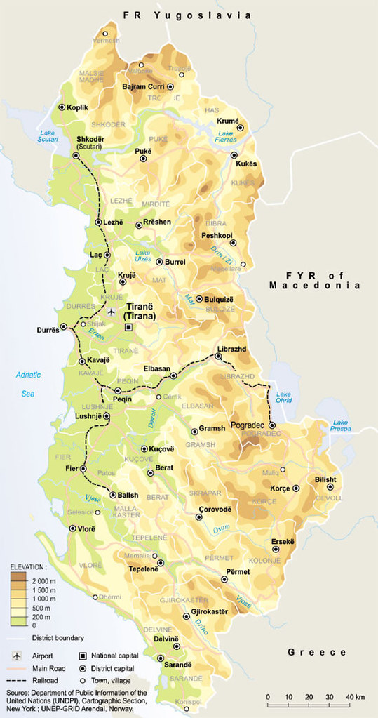
  • Albania, topographic map with railroad routes

    Albania, topographic map with railroad routes

  • Slovakia, topographic map

    Slovakia, topographic map

  • Czech Republic, topographic map

    Czech Republic, topographic map

  • Moldova, topographic map

    Moldova, topographic map

  • Russian Federation, topographic map

    Russian Federation, topographic map

  • Antarctica, topography and bathymetry (topographic map)

    Antarctica, topography and bathymetry (topographic map)

  • Uzbekistan, topographic map

    Uzbekistan, topographic map

  • The Caspian Sea Drainage Basin

    The Caspian Sea Drainage Basin

  • Antarctica, overview

    Antarctica, overview

  • Barents Region, topography and bathymetry

    Barents Region, topography and bathymetry

  • Tanzania case study, locator map

    Tanzania case study, locator map

  • Topography and hydrography of the Ferghana Valley

    Topography and hydrography of the Ferghana Valley

  • Yugoslavia, topographic map

    Yugoslavia, topographic map

  • Tajikistan, topographic map

    Tajikistan, topographic map

  • Bosnia and Herzegovina, topographic map

    Bosnia and Herzegovina, topographic map

  • Discards as percent of overall catch, 1988-1992

    Discards as percent of overall catch, 1988-1992

  • Deforestation in Rondonia (Brazil)

    Deforestation in Rondonia (Brazil)

  • Tourism in the Antarctic

    Tourism in the Antarctic

  • Contribution of fish to human diet, 1987-1989

    Contribution of fish to human diet, 1987-1989

  • Deforestation in Amazonas

    Deforestation in Amazonas

  • Antarctic specially protected areas (ASPA)

    Antarctic specially protected areas (ASPA)

  • Coastal Arctic food web (drift ice)

    Coastal Arctic food web (drift ice)

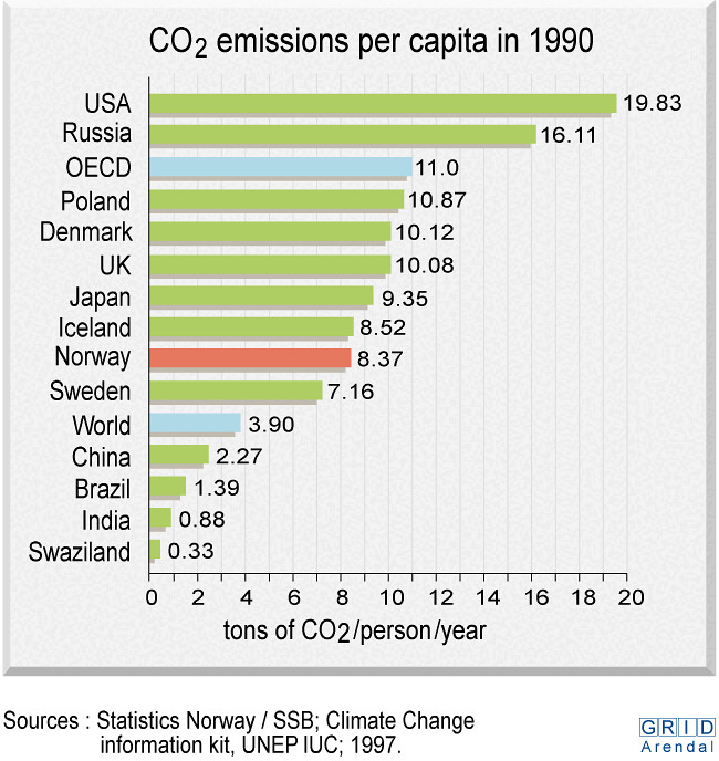
  • CO2 emissions per capita in 1990

    CO2 emissions per capita in 1990

  • Coral reefs at risk from human activities

    Coral reefs at risk from human activities

  • Long range transport of air pollutants to the Arctic

    Long range transport of air pollutants to the Arctic

  • Statistical Distribution of Alkalinity

    Statistical Distribution of Alkalinity

  • Energy supply in 1994

    Energy supply in 1994

  • « Previous
  • 1
  • …
  • 330
  • 331
  • 332
  • 333
  • 334
  • …
  • 344
  • Next »
Connect With Us

2026 GRID-Arendal Disclaimer Policies

Except where otherwise noted, content on this site is licensed under a Attribution-NonCommercial-ShareAlike 4.0 International Licence

×