

- Single Image File
Environmental hotspots on the Mediterranean coast
A graphic overview identifying the environmental hotspots and ares of major environmental concern on the coast of the Mediterranean Sea.

- Single Image File
Sea level variations in the Mediterranean
Sea level is rising significantly in the Eastern Mediterranean, with an average 12 cm rise registered on the Levantine coast since 1992. However, causes…

- Single Image File
Industrial hazardous waste in the Mediterranean countries
Industry is frequently located along the region’s coasts in areas with high population density, sometimes within urban centers, and often in close proximity to…

- Single Image File
Coastal erosion (EU) and fragile ecosystems in the Mediterranean
Among the many impacts erosion has on coastal ecosystems are the destruction of soil surface layers, leading to groundwater pollution and to reduction of…

- Single Image File
Mean surface salinity
Schematically, the Mediterranean Sea comprises three main water masses (EEA and UNEP 1999): • the Modified Atlantic Water (MAW), found in the surface layer,…
- Single Image File
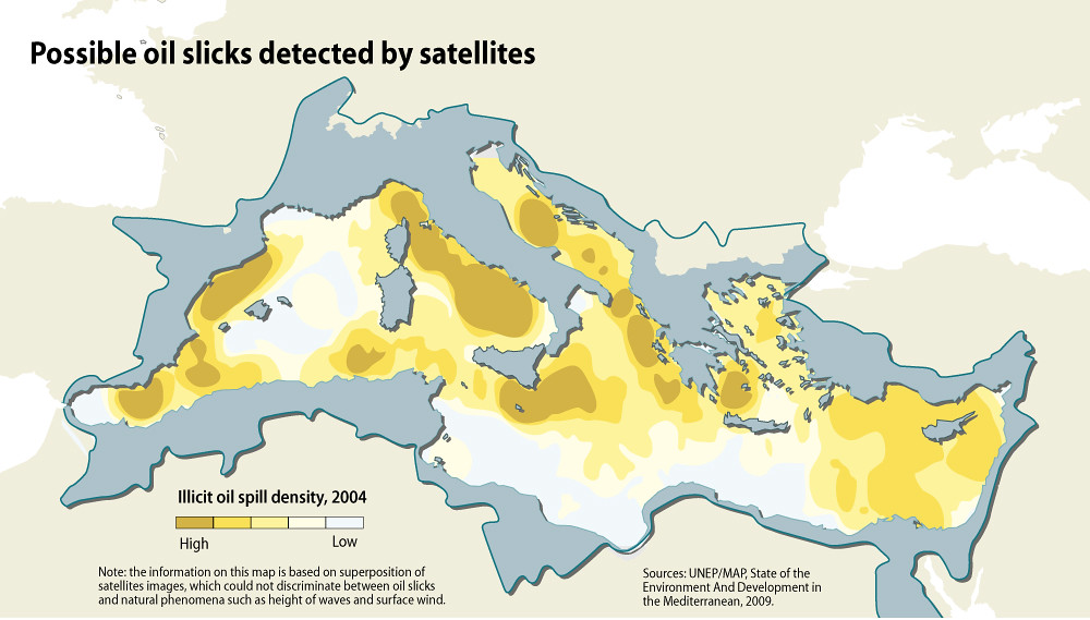
Possible oil slicks detected by satellites
Illicit vessel discharges can be detected using satellite images, allowing the estimation of the spatial distribution of oil-spill density and the identification of hot…

- Single Image File
Aquaculture in the Mediterranean and Black seas
Aquaculture is the fastest growing food sector in the world, with about one-third of global fish consumption coming from farmed fish.More than half of…

- Single Image File
Mean concentrations of trace metals and Persistent Organic Pollutants (POPs)
The term trace metal is used here for potentially toxic metals that persist in the environment, bioaccumulate in human and animal tissues, and biomagnify…
- Single Image File
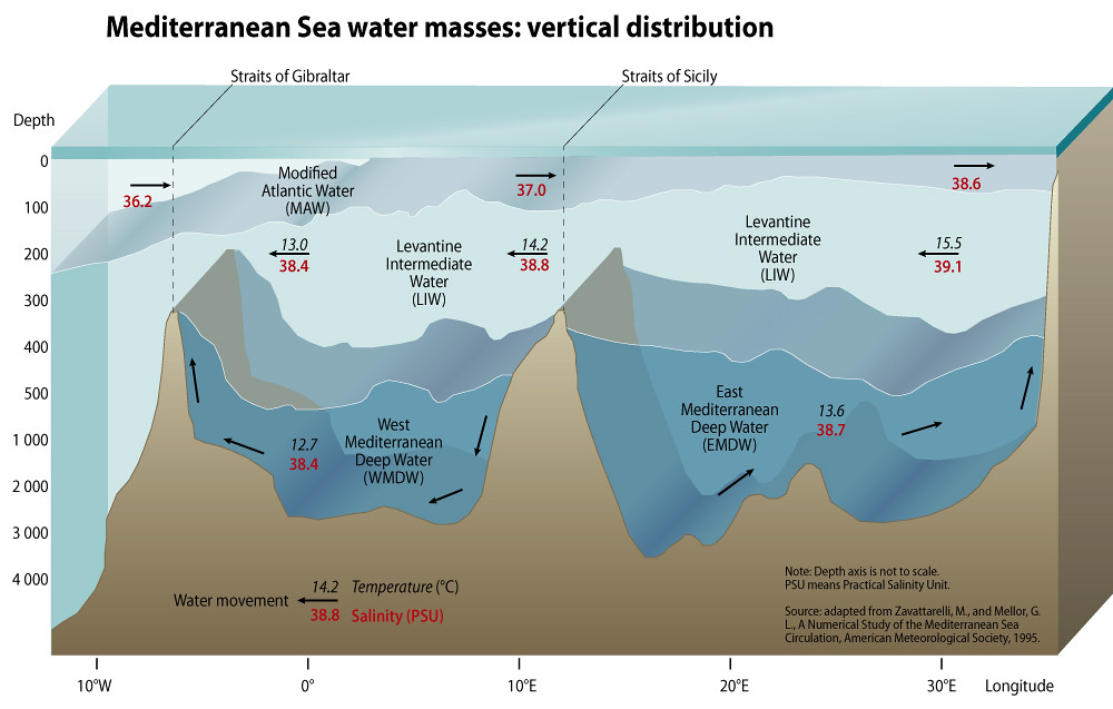
Mediterranean Sea water masses: vertical distribution
Schematically, the Mediterranean Sea comprises three main water masses (EEA and UNEP 1999): • the Modified Atlantic Water (MAW), found in the surface layer,…

- Single Image File
Yugyd Va (Komi Ural) National Park, Komi Republic, Russia
The Yugyd Va National Park covers 18,917 square kilometres in the Northern Ural Mountains and adjacent foothills and flatlands. The entire park is within…

- Single Image File
Nenets celebrating, Pechora Delta, Nenets Autonomous Region, Russia
The Nenets, also known as Samoyeds, are an indigenous people in northern arctic Russia. According to the latest census in 2002, there are 41,302…
- Single Image File
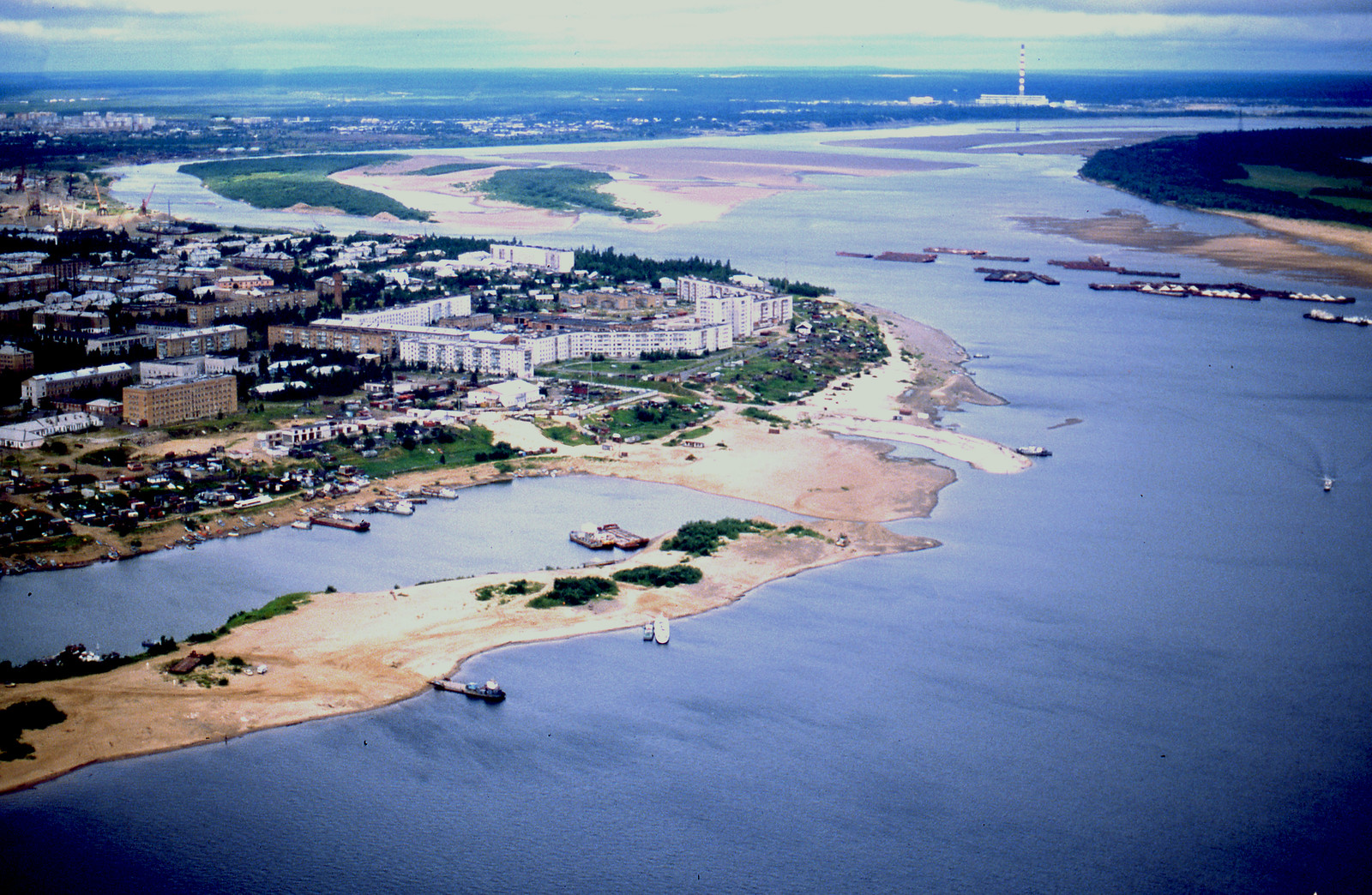
Pechora River, Komi Republic, Russia
Pechora is a town in the Komi Republic, Russia, located on the Pechora River, near the northern Ural Mountains. Population: 43,105 (2010 Census).