

- Single Image File
Change in proportion of land area covered by forests in Zimbabwe
An initial impact of land reform was deforestation as forests were cleared to accommodate larger numbers of farmers, but the impact is yet to…

- Single Image File
Population using improved drinking water sources in Botswana
Due to deliberate policy and strategic action, Botswana is in the envious position of having met its water and sanitation targets well before the…

- Single Image File
Zambezi River Basin flood areas
Over the last two decades, the Zambezi River Basin has experienced extreme floods and droughts (SARDC and HBS 2010). Most of the flooding in…

- Single Image File
Proportion of urban dwellers living in slum conditions in Tanzania
The population living in unplanned peri-urban settlements has been decreasing as a proportion of total urban population, while the urban population has also been…

- Single Image File
Protected areas share of total land area in Namibia
Tanzania has the second highest proportion of national protected areas among the Basin states, after Zambia, with 28% of the country set aside for…

- Single Image File
Sanitation trends in Zimbabwe
Progress in achieving water and sanitation targets is off track. Urban water and sanitation systems are in urgent need of renewal, and have faced…

- Single Image File
Consumption of ozone layer depleting substances in Mozambique
The extent of carbon emissions is not well documented in Mozambique and is not considered a significant factor in environmental sustainability. While the consumption…

- Single Image File
Map of Angola
Total Area of Country: 1 246 700 sq km Portion of Country within Zambezi Basin: 256 500 sq km (20.5%) National Population in 2010:…
- Single Image File
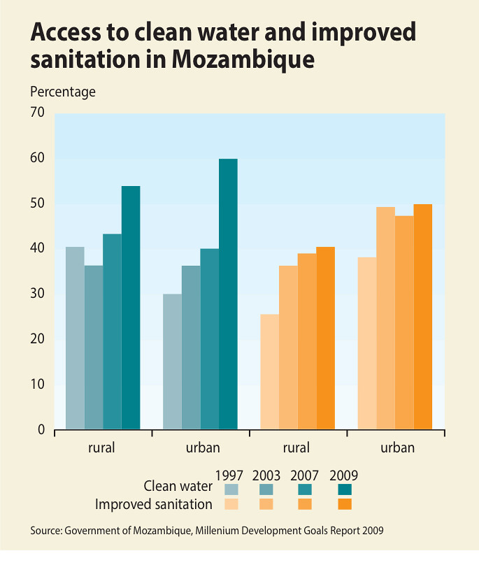
Access to clean water and improved sanitation in Mozambique
The proportion of the population with access to safe drinking water has increased significantly to 56% in 2009, from 37.3% in 1997. The national…

- Single Image File
Map of Zambia
Total Area of Country: 752 614 sq km Portion of Country within Zambezi Basin: 577 900 (76.8%) National Population in 2010: 13 million Portion…

- Single Image File
Urban Population in Zambezi River Basin States
Zambezi River Basin countries share similar settlement patterns characterized by both low and high densities. While the basin is largely rural, urbanization rates are…

- Single Image File
Map of Mozambique
Total Area of Country: 799 390 sq km Portion of Country within Zambezi Basin: 163 800 (20.5%) National Population in 2010: 22.4 million Portion…