

- Single Image File
Freshwater biodiversity and poverty in Eastern Africa
Red areas where high percentage of children with stunted growth - used as a proxy for poverty - coincide with a high freshwater biodiversity…
- Single Image File
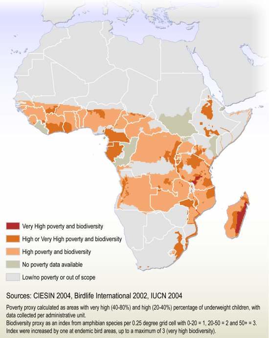
Relationship between biodiversity and poverty in Africa
This map may be used to show areas in which biodiversity is threatened in relation to poverty on a continental scale. Areas where high…
- Collection
Reference maps
Locational maps, greatly simplified to just communicate the locations of points of interest, such as cities or regions.
- Collection
Poverty-biodiversity mapping applications
Discussion paper for the session "Decision-support systems - Their value in addressing health-poverty-conservation links" at the IUCN World Conservation Congress, November 17-25 2004, Bangkok,…

- Single Image File
Global poverty-biodiversity map
This map may be used to show areas in which biodiversity is threatened. Areas where high poverty and high population density coincides with high…

- Single Image File
Global development and biodiversity
Some of the world's least developed countries are located in hotspot areas of high importance for biodiversity. This map displays Human Development Index (UNDP)…
- Collection
Baltic GIS
The Baltic Sea Region GIS, Maps and Statistical Database is a result of the Baltic Drainage Basin Project (BDBP), a multi-disciplinary research project under…

- Single Image File
The Baltic Sea Drainage Basin
This 'basemap' displays the extent of the drainage basin (the boundary for the water that ends up in the Baltic Sea), and the countries…

- Single Image File
Arable Land in the Baltic Sea Region
Ratio of arable land out of total land use in the Baltic Sea drainage basin. Agriculture is one of the main contributors to the…

- Single Image File
Wetlands in the Baltic Sea Drainage Basin
Percentage of wetlands out of total land area (by grid cell) for the Baltic Sea drainage basin. Wetlands acts as buffers in cases such…

- Single Image File
Pasture Land in the Baltic Sea Drainage Basin
Ratio of pasture land total land use in the Baltic Sea drainage basin. Agriculture is one of the main contributors to the nutrient (in…

- Single Image File
Population Density in the Baltic Sea Drainage Basin
The density of people per square kilometres have been calculated from various statistical sources, and displays the situation at approximately 1990. Population, and specifically…