

- Single Image File
Monthly average sea ice extent globally and in both hemispheres (radial)
In the Arctic, winter sea ice extends over an area of approximately 15 million km2 at its peak in March and up to 7…

- Single Image File
Historical trends in carbon dioxide concentrations and temperature, on a geological and recent time scale
The most recent geological history, in the last hundred thousand years, has been characterized by cycles of glaciations, or ice ages. The historic temperatures,…

- Single Image File
Glaciers monitored through the World Glacier Monitoring Service
Worldwide collection of information about ongoing glacier changes was initiated in 1894 with the foundation of the International Glacier Commission at the 6th International…

- Single Image File
Ratio of existing ski areas in the Alps with natural snow-reliability under current conditions and warmer conditions
Winter tourism is a significant part of the economy of Alpine countries and the most important source of income in many regions. In Austria,…

- Single Image File
Mountain permafrost patterns and temperature gradients
Steep terrain and strong variability in surface temperatures are typical of mountain permafrost. The cross section in the foreground shows the complex distribution of…
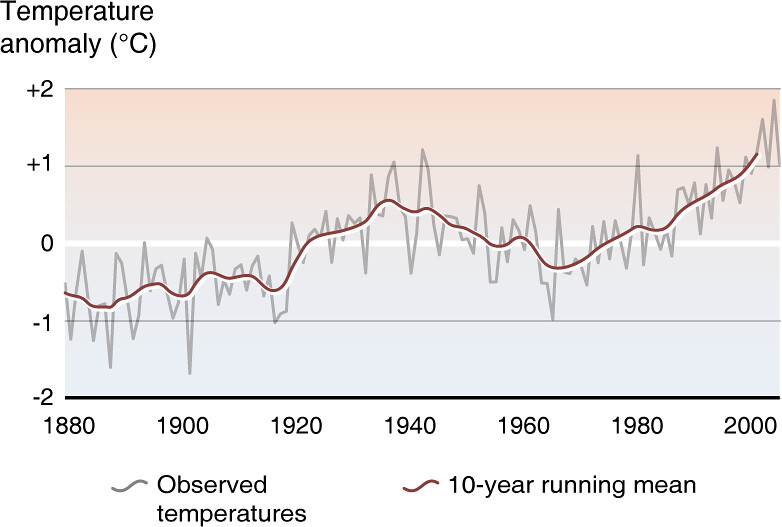
- Single Image File
Trends in Arctic temperature, 1880-2006
A history of Arctic land temperature anomalies from 1880 through 2006 is shown in this figure. The zero line represents the average temperature for…

- Single Image File
Projected changes in permafrost (Northern Hemisphere)
Modeled permafrost temperatures (mean annual temperature at the permafrost surface) for the Northern Hemisphere (Arctic), derived by applying climate conditions to a spatially distributed…

- Single Image File
The Cryosphere, world map
Snow and the various forms of ice - the cryosphere - play different roles within the climate system. The two continental ice sheets of…

- Single Image File
Arctic delta pond ecosystems, seasonal flooding and adaptation
The physical development and ecosystem health of river deltas in cold regions are strongly controlled by ice processes and thus are highly susceptible to…

- Single Image File
Showing rates of surface-elevation change derived from satellite radar-altimeter measurements, Antarctica
The figure shows rates at which the ice-sheet mass was estimated to be changing based on radar-altimeter data (black), mass-budget calculations (red), and satellite…

- Single Image File
Population size of Peary caribou in the Canadian Arctic islands
In northwestern North America, recent warming has led to a dramatic increase in the number of days of above freezing temperatures during the migration…

- Single Image File
Mass balance reference glaciers in nine mountain ranges
Thirty reference glaciers with almost continuous mass balance measurements since 1975 show an average annual mass loss of 0.58 m water equivalent for the…