

- Single Image File
Statistical Distribution of Alkalinity
Measuring alkalinity determines a stream's ability to neutralize acidic pollution from rainfall or wastewater. Alkalinity refers to the ability of water to resist change…

- Single Image File
Long range transport of air pollutants to the Arctic
The major industrial areas of the Northern Hemisphere are a source for long range transport of pollutants. The main air currents are taking industrial…

- Single Image File
Coral reefs at risk from human activities
Population growth and technology: operating together these two factors account for the major causes of coral reef decline - excessive domestic and agricultural waste…
- Single Image File
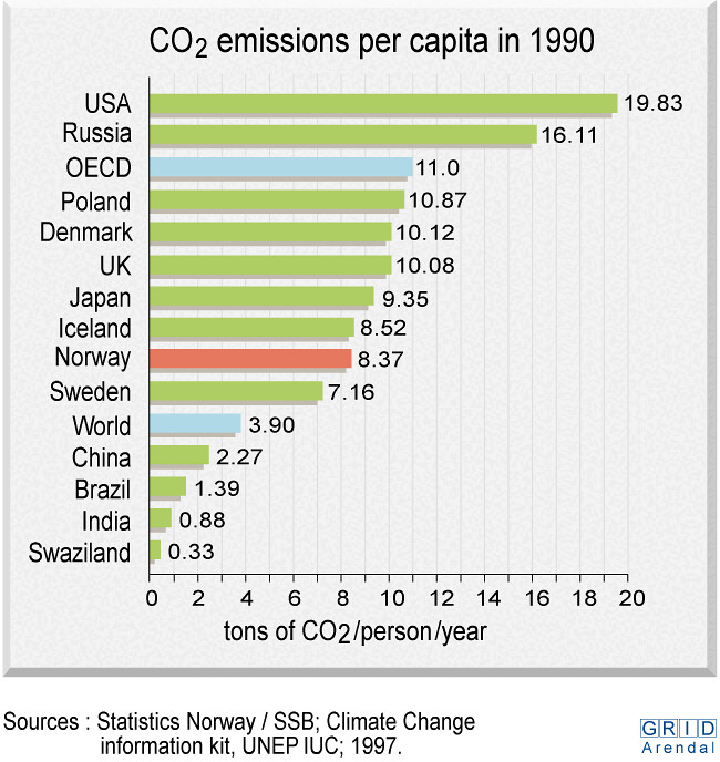
CO2 emissions per capita in 1990
The graph shows emissions of CO2 per capita 1990. CO2 can be emitted as byproduct from the use of fossil fuel, by combustion, land-use…

- Single Image File
Coastal Arctic food web (drift ice)
The coastal Arctic food web is closely related to drift ice conditions and seasonal use of shorelines by both terrestrial and sea mammals. Numerous…

- Single Image File
Antarctic specially protected areas (ASPA)
The 1961 Antarctic treaty system, which governs the land and water south of 60 degrees latitude south, gives the environment an overall protection against…

- Single Image File
Deforestation in Amazonas
The amount of deforestation in the Amazon region is increasing at an alarming rate. This graphic compares the amount of deforested areas in the…

- Single Image File
Contribution of fish to human diet, 1987-1989
The percentage of fish to the total human diet from various regions in the world. Based on statistics from 1987 to 1989. Fish is…

- Single Image File
Tourism in the Antarctic
the graph shows the number of tourist and ships going to the Antarctic from 1981 to 1996. It shows a steady increase of both…

- Single Image File
Deforestation in Rondonia (Brazil)
The graph shows deforestation in Rondonia, Brazil. Brazil covers more than one quarter of the worlds tropical forests. Since 1980 the deforestation has steadily…

- Single Image File
Discards as percent of overall catch, 1988-1992
The graphic shows the amount of discards in the fishing industry from 1988 to 1992. It is broken down into overall, fish, crustaceans and…

- Single Image File
Bosnia and Herzegovina, topographic map
Bosnia and Herzegovina is located in Southeastern Europe, bordering the Adriatic Sea and Croatia, comprising of 51,129 sq km. It has a population of…