

- Single Image File
Types of Aquifers, Wells and Groundwater Flow
This graphic illustrates groundwater flow, two types of aquifers (confined and unconfined) and three types of wells (artesian; flowing artesian and a water table…

- Single Image File
Major River Basins of the World
Rivers form a hydrological mosaic, with an estimated 263 international river basins covering 45.3% of the land surface area of the earth, excluding Antarctica.…

- Single Image File
What Causes the Sea Level to Change?
A significant sea level rise is one of the major anticipated consequences of climate change. This graphic explains the causes of sea level change…

- Single Image File
Global Dissolved Phosphate Levels
A comparison of the major watersheds between the two decades showed that Northern Europe and North America had lower phosphate concentrations, while the Ganges…

- Single Image File
Global Water Withdrawal and Consumption
Freshwater use is partly based on several socio-economic development factors, including population, physiography, and climatic characteristics. This graphic illustrates freshwater use, in cubic kilometres…
- Single Image File
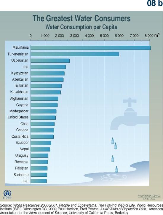
The Greatest Water Consumers
Freshwater use is partly based on several socio-economic development factors, including population, physiography, and climatic characteristics. This graphic illustrates the world's top 20 water…

- Single Image File
The carbon cycle

- Single Image File
Benefits from Marine and Coastal Ecosystems and Activities
Besides the well-known economic value of fisheries, there are several other activities generating significant revenues in coastal and marine areas. This graphic discusses the…

- Single Image File
Turning the Tides: Regulation of the Tigris and Euphrates Rivers
Water has long been associated with conflicts between neighboring countries. This graphic shows how water from the Tigris and Euphrates rivers is used in…

- Single Image File
The Major River Basins of Africa
This map shows the locations of 13 major river basins in Africa: the Senegal, Volta, Niger, Lake Chad, Nile, Lake Turkana, Juba Shibeli, Ogooue,…
- Single Image File
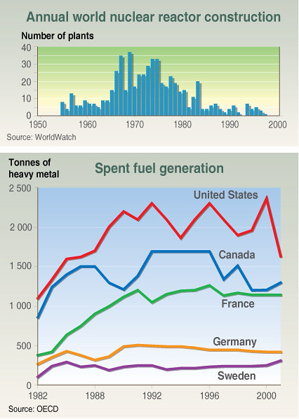
Annual world nuclear reactor construction
Both the volume and the level of radioactivity have to be considered – a large volume of waste with a low-level of radioactivity presents…

- Single Image File
Ability of countries to support their citizens from their own environment
The Ecological Footprint measures the amount of productive land area needed to support a nation’s consumption and waste. This indicator shows that in many…